Introduction
According to the IPCC (Government Special Committee on Climate Change) 5th Assessment Report (AR5) summary for decision makers, it is proposed that the changes in sea temperature that the world will face in the future will cause one of the major impacts on industrial livelihoods of coastal residents, and will affect the health of long-term outdoor workers due to the impact of high temperature
Due to its special natural environment, ecosystem, landscape features, history and culture, spatial pattern, and breeding industry, Tainan's coastal area is a precious area for Taiwan. However, under the environmental changes, besides the global climate change issues mentioned above, regional field changes and human and social changes have exacerbated existing problems and challenges.
Due to its special natural environment, ecosystem, landscape features, history and culture, spatial pattern, and breeding industry, Tainan's coastal area is a precious area for Taiwan. However, under the environmental changes, besides the global climate change issues mentioned above, regional field changes and human and social changes have exacerbated existing problems and challenges.
Our research
The highlight of this year is the adaptation strategy for the high temperature environment of the outdoor environment in the southern coastal area. The introduction of the environmental control courses allows students to make preliminary observations through the online media, have site visit and interviews with local residents, it was found that the local outdoor working environment and hot conditions in the sightseeing area will reduce foreign tourists' willingness to visit there. And it will also reduces the work effectiveness of the local residents as they cannot work under the high temperature outside for a long time.
In order to effectively solve the hot outdoor environment in the coastal area of the south, and integrate local natural landscape to build a suitable localized resting space, in addition to on-site environmental surveys and interviews with local residents, the central weather data is used to integrate and analyze the natural climate of the field. Using aerial photography technology to build a 3D model of the outdoor environment in the coastal area, and use the simulation software Flowdesigner to simulate the outdoor natural environment situation, to achieve a detailed analysis of the field environment.
In order to effectively solve the hot outdoor environment in the coastal area of the south, and integrate local natural landscape to build a suitable localized resting space, in addition to on-site environmental surveys and interviews with local residents, the central weather data is used to integrate and analyze the natural climate of the field. Using aerial photography technology to build a 3D model of the outdoor environment in the coastal area, and use the simulation software Flowdesigner to simulate the outdoor natural environment situation, to achieve a detailed analysis of the field environment.

Evaluation of surface temperature in Beimen by thermal imaging camera, parking lot near tourist centre (left), Crystal church (right)
In addition, the education of the thermal environment also cooperates with Shang Kai Steel Co. Ltd through the summer service camp to digitally analyze the outdoor environment and provide the best shading solution. And applied to salt and humidity resistant coatings for participants to understand that proper use of materials can effectively reduce the ambient temperature.

Use the software to simulate the best shading result. The shading cube was displayed in the Seafood Festival in Cigu. (centre, right)
The research results of this topic students use the aerial base maps provided by Professor Jiann-Yeou Rau from Department of Geomatics to analyze the Arc GIS overlay. The orthophotos taken through the aerial experiments are imported into the mosaic software for synthesis processing, importing the geographic information system to digitize the layers, according to the low-lying areas, establish a layer of high probability flooding areas, and investigate the dictation of residents through the community to establish a layer of actual flooding areas. In the two districts, the difference between the predicted low-lying susceptible flooding and the actual flooding range is too large, because the underground drainage system is not considered.
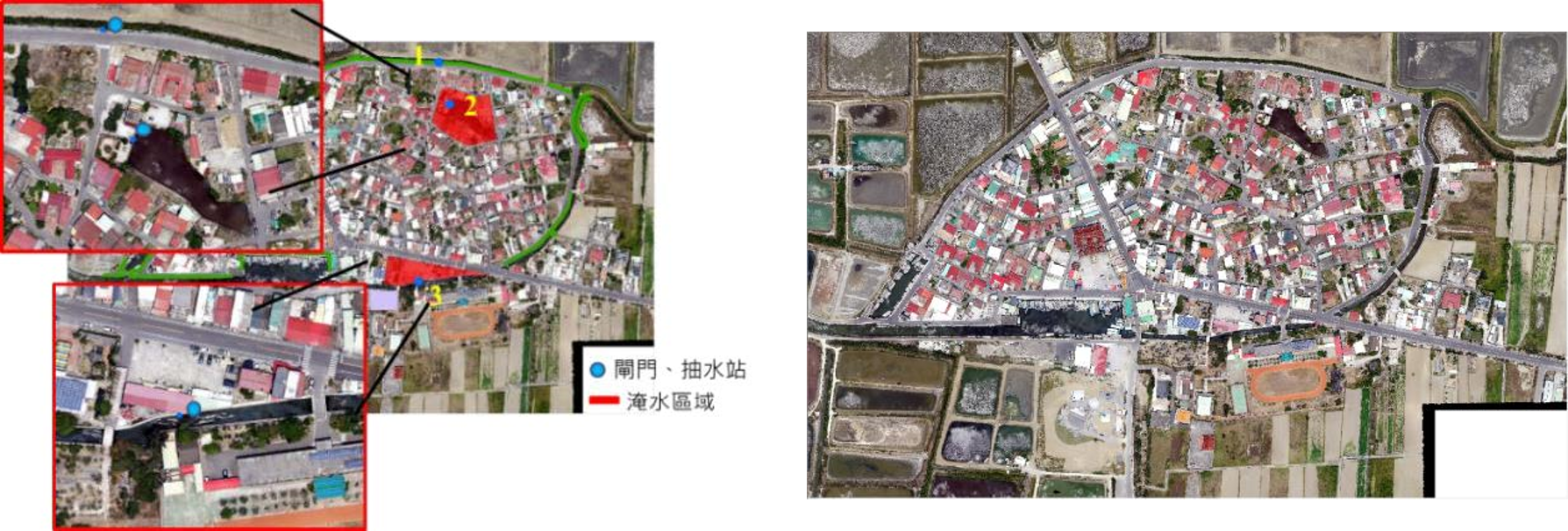
Aerial shot of Cigu district
Related events
|
|
Off - school teaching of San-Gu Elementary School
2019.05.17 Sangu, Qigu District, Tainan City The Department of Geomatics and Department of Architecture of NCKU went to Sangu Elementary School on the morning of May 17,2019, and integrated 3D modeling, aerial photography, climate monitoring, environmental simulation, architecture and environmental control into the fifth-grade nature class of Sangu Elementary School, and Propose strategies for thermal environment adjustment. Based on the innovative education ideas of the IMPACT team and the principal San-Gu Elementary School, combined the actual measurement with the improvement of the school's weather environment, allowing students to apply scientific knowledge to the improvement of living areas in the process of detecting problems, exploring the causes, and formulating solutions, to train children to use scientific knowledge to think and solve problems. See Chinese version for news |
|
|
Bamboo structure testing in Beimen
2019.03.28 Crystal Church, Tai'an Temple, Beimen On March 28, 108, the project assistant conducted temperature measurement for the newly-built bamboo structures in Beimen, and provided data to show that structures can help to cope with the high-temperature environment of Beimen and provide a shelter for tourists. The structures were built near the Crystal Church and Tai'an temple, while two sets of instruments were located in the The structures and a set of control instruments were located outside the one near the Crystal Church. |
